| W/Ch 2000 Location: Landres, France |
Some have asked me where the W/Ch 2000 site is situated, hence this page. As the Landres web site grows, this may become superfluous. Updated Dec 3.
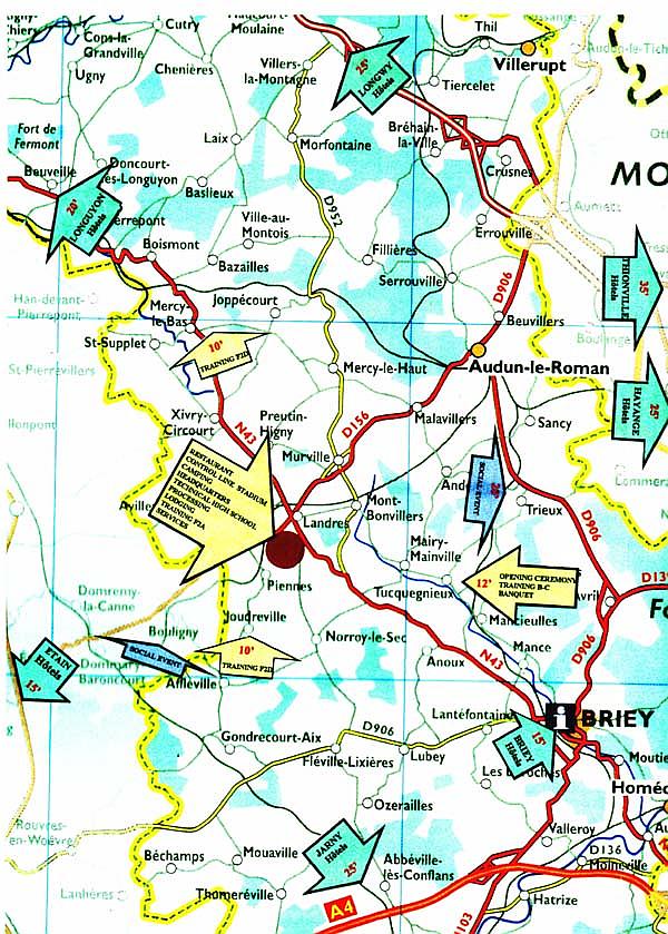
Landres is too small to appear on many maps. Sometimes the contest site is called Piennes, from the neighbouring town, likewise absent from most maps.
I haven't been at the W/Ch site, but here are some hints, taken from the world atlas at my job:
Landres and Piennes are found around 35 kilometres northwest of Metz, or around 260 kilometres east of Paris.
Landres is 26 kilometres straight south from the point where the borders of Belgium, Luxemburg and France join.
Piennes is around 2.5 kilometres south to southwest of Landres.
All distances are straight-line.
The Organizers' Web Site provides this local map, which I have sharpened here, for better readability.
For those of you who have become GPS dependent:
Landres: 49° 19' N - 5° 49' E
Piennes: 49° 18' N - 5° 47' E
CAUTION: There is another place called Landres around 50 kilometres to the west of "our" Landres!!!
For conversion of kilometres to miles, visit my Units Conversion Page!
Hello Goran,
It is good idea to add a picture how to find Landres. I had lots of problems to find it first time too.
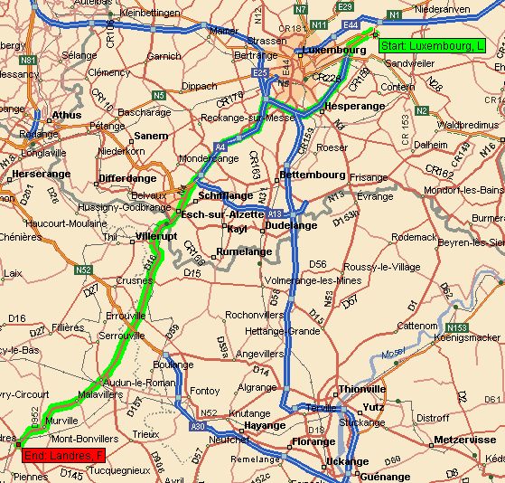
Anyway I think it can be important how get to Landres from Luxembourg. The airport in Luxembourg is the closest large airport (50 km).
Here is the map and itinerary from Autoroute 98. I am also sending
a description how to go that way with some helpful hints written by
Luxembourg resident Gabriel Honnert. He is also director of "Grand Prix
of Luxembourg" which should be moved to May next year. It could be a good
idea to note it on your web too. It could be the last "sharp" training before
the WC2000.
| Time | Distance | Instruction | Road | For | Direction | |
|---|---|---|---|---|---|---|
| 0:00 | 0.0 | Depart Luxembourg, L | Local road(s) | 386 m | W | |
| 0:00 | 0.4 | Bear left onto | N1 | 3.1 km | W | |
| 0:03 | 3.4 | Go onto | Local road(s) | 7.0 km | S | |
| 0:07 | 10.5 | At Luxembourg-Sud, go onto | E25 | 2.7 km | W | |
| 0:09 | 13.2 | At A4-E25, turn left onto | A4 | 10.1 km | S | |
| 0:14 | 23.3 | Go onto | N4 | 3.8 km | SW | |
| 0:20 | 27.1 | Go onto | Local road(s) | 53 m | W | |
| 0:21 | 27.1 | Entering France | ||||
| 0:21 | 27.1 | Go onto | D16 | 9.9 km | W | |
| 0:31 | 37.0 | Go onto | D906 | 4.2 km | SW | |
| 0:35 | 41.3 | Go onto | D156 | 10.1 km | SW | |
| 0:44 | 51.3 | Arrive Landres, F |
I suppose you are on the highway Luxembourg-city to Esch. Stay on the highway and drive straight on towards the end of it (do not use the exit Esch-Alzette.) At the end there is a roundabout, drive trough it 3 and head towards direction: FRANCE. There will be about 4 more roundabouts (just to make you dizzy). Cross the border and drive through Audun-le-Tiche. At the 2nd traffic junction drive left and directly afterwards right. There is a green road sign who shows: Thionville. If you done it right you will be driving uphill towards AUMETZ. 5kms. In Aumetz drive left at the the first junction, then afterwards directly right, direction Audun-le Roman. This is the main direction you should never leave anymore 'till Landres. In doubt, the right direction is always ETAIN! Little town: Beuvilliers. In Audun-le Romain keep driving straight (Etain). Little town: Malaviliers. At Landres drive straight through the roundabout, direction Piennes. At your left side you will see some Supermarkets (Intermarché and Gamme Vert). Drive uphill and turn left opposite to the road sign: LANDRES-Citées There is also a green and blue Water tower. This is the road (RUE DE LA MINE) who leads to the airfield. Bus station & Glass container. Welcome. If you went over the hill you'll see a sign; PIENNES. In this case you missed it, you went too far.
Igor